First half of April: COVID-19 Spread in Europe - Animated Map
Channel:

Subscribers:
4,490
Published on ● Video Link: https://www.youtube.com/watch?v=JTxDZTsLDrk
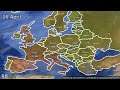
An animated map of the Coranavirus spread in Europe from the 26th of March to the 16th of April, based on Wikipedia numbers. Treat the video as an estimate. Hazard signs are the relative size of spread while the coloured countries and numbers are the amount of dead.
Other Videos By RB33z
Tags:
Stats
Statistics